The routes drawn on this map utilize the
OpenStreetMap API. As such, there are situations in which a route cannot be displayed. The code takes
your starting point, then calculates points directly North, South, East, and West of your origin. The code then gets driving directions toward each point.
For illustration, let's say you entered a distance of 100KM. The N, S, E, W points are exactly 100KM from your
point of origin, but if you draw the route along the road all the way to the end point, the route will be more than 100KM. So, the code calculates the distance to display along the road.
But, if there are no roads where the end points lie, the driving directions cannot be generated and no route will be shown.
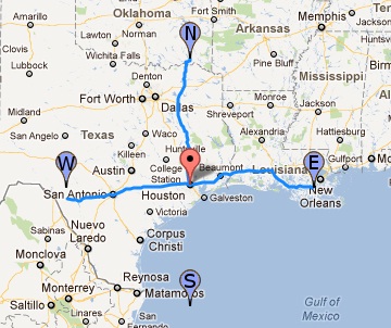
In the following example, the point to the south is out over the Gulf of Mexico No roads, no driving directions, hence, no route.
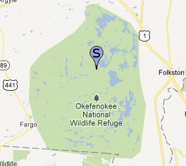
Likewise, the next example illustrates the lack of roads impacting the available driving directions.Why is there no route to the south?
Turns out the point to the south lands in the middle of the Okefenoke National Wildlife Refuge. No roads, no driving directions, hence, no route.